We can firm up for sure that Cyclone is not expected to come close to TN coast as it is getting strengthened in open waters and we can forget any direct rainfall from the Cyclone. Indirect thunderstorms will form in interiors and will move towards the coast. While pleasant summer is going to end in few days and spike of above is expected from 19th May. Have tried to explain the reasoning as much through the images, do have a look into it.
Please read the previous post before reading further –

1. Thunderstorms in TN/AP/Karnataka till 19th May
———————
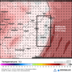
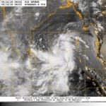
As long as Cyclone moves up beyond Andhra there will be Thunderstorms till 19th May, there will be massive towering thunderstorms which will be forming inland in Interior Tamil Nadu, Interior Karnataka and Andhra Pradesh. We will never know where it bloom, but these indirect rains from Cyclone can be filled with Thunder, Lightening and sudden spells of intense rains in short period. These clouds will move towards the coast too or one outer band from cyclone might fall over some coastal places, if lucky some places in Tamil Nadu coast will see intense rains too. So still rains chances from thunderstorms or one stray outerband exist based on pure luck for us, but it will be isolated ones. Kerala rains, please refer previous post.
Bangalore has chance of intense thunderstorms on 17-18th May.
Chennai rain chances depends upon movement of thunderstorms from interiors or some stray bands falling over us. So both pure luck.
2. Heat to Jump in Chennai, TN and AP from 19th May
—————–
Chennai had one of the best Summer so far with not even crossing 37 C till date, but this will all change from 19th May.
1st May – 35.1 C
2nd May – 36.6
3rd May – 36.0
4th May – 35.4
5th May – 35.3
6th May – 35.3
7th May – 35.0
8th May – 36.5
9th May – 36.5
10th May – 35.7
11th May – 35.6
12th May – 35.5
13th May – 35.4
14th May – 36.3
15th May – 36.0
The blessed days are coming to over with easterlies coming to abrupt end from 19th May. Once Cyclone moves up beyond Andhra, we will get dry NW winds and also the off shore winds will be strong this means easterlies which was keeping temp at check will not exist and sea breeze will struggle to come in with strong land-breeze from west and strong offshore winds too will keep prolonged heating. Last time Chennai City (Nungambakkam) saw 43 C was way back in 2007. The cyclone will take all the moisture away.
All time Chennai Hottest days ever in May month
—————-
45 C in 31.05.2003 (Cyclone curved to Burma)
44.1 C in 30.05.1998 (Cyclone curved to Burma)
43.6 C in 23.05.1980
43.4 C in 12.05.2002 (Depression to Burma)
43.2 C in 04.05.1976 (Depression to Burma)
Last time Chennai crossed 43 was 16.05.2007 – 43 C
The one good news is that all the above hot days are due to cyclone curved away to Burma. While Bengal / Bangladesh bound systems have not given 43C so far for the city. So less chances for Chennai City Temp to go beyond 43 C. While Meenambakkam will be 1 C hotter than City being little inland. We can surely expect City to record 41-42 C while meenambakkam will be notch higher. Almost all areas close to coast will sizzle. Keep an eye on Tiruttani and Vellore. They will top temperature with ease.
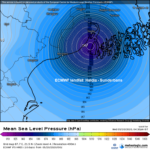
3. Consensus among models and time of landfall.
——————————————-
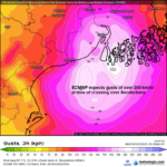
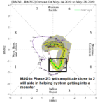
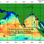
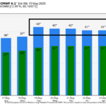
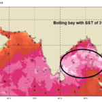
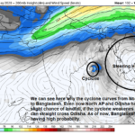
MJO in P3, high SST of 30-31 C, TCHP of over 100 kj/cm2, High pressure in NE giving perfect outflow, low shear now all are conducive for a monster storm in bay, No wonder models intensify and show crazy pressure numbers. The shear is found increasing near Odisha coast so ECMWF and GEM weakens the system a bit, while GFS and ICON maintain low shear throughout their travel., this is may month what else you can expect. So a strong cyclone.
ECMWF – 958 mb system crossing Bengal/Bangla Border on 20th Night
ICON – 942 mb system crossing Bangla/Burma Border on 20th Morning
GFS – 941 mb system crossing Bangla on 20th Evening
GEM – 962 mb system crossing Bangla on 20th Night
HWRF – 899 mb system crossing Bangla/Burma Border on 20th Morning
BOM – 909 mb system crossing Bengal on 20th Noon
JMA – 980 mb system crossing Bangla on 21st Evening
WRF – 974 mb system crossing Bangla on 21st Morning
Navygem – 931 mb system crossing Bengal/Bangla Border on 19th Night
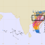
Except UKMET model which shows, North Andhra and NCUM which shows Odisha, all models agree in Bangladesh.


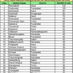
 Not only landfall, the cities where cyclone passes as cyclone at night is put below. So people has to stay indoors in these places at night in West Bengal.
 5. Storm Surge – 5 mts