Dhanushkodi was once an active town of fisherfolks but it was ravaged by one of the strongest cyclone ever to hit Tamil Nadu in December 1964. Most of the strongest cyclones to Tamil Nadu have come late in December Eg. 2011 Cyclone Thane, 2000 Sri Lanka Cyclone and 1964 Rameswaram Cyclone. These are strong cyclones with wind speeds over 150 km/hr. Prior to 2004 cyclones names were not given in India seas and the place where it crosses that name would be given.
Courtesy NoAA
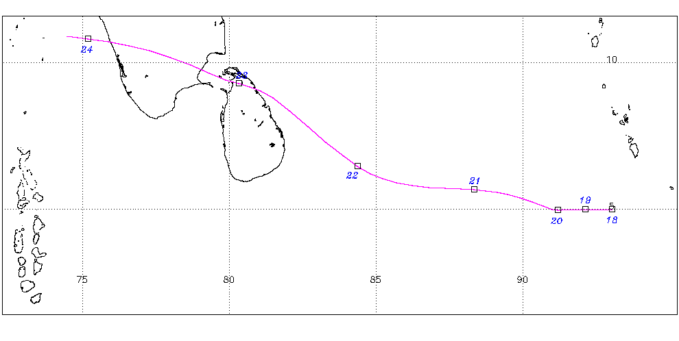
Most Cyclones avoid Sri Lanka
There is always a question among weather blogging community. Of the 100s of Cyclone crossing Tamil Nadu only few have crossed Sri Lanka 1964, 1978, 1992, 2000 as strong cyclone. For reasons not known, the cyclones always tend to avoid the rugged terrain of Sri Lanka and move up towards Delta or Cuddalore or Chennai or South Andhra. At that time in 1964, the Rameswaram Cyclone was the 1st severe cyclone storm to move into Palk Strait in 80 years. It is evident that those seas in Palk Strait is not used to be visited by severe cyclones in their history. Weak Depression or cyclones might have moved there in those area in the past.
First Severe Cyclone in Palk Strait
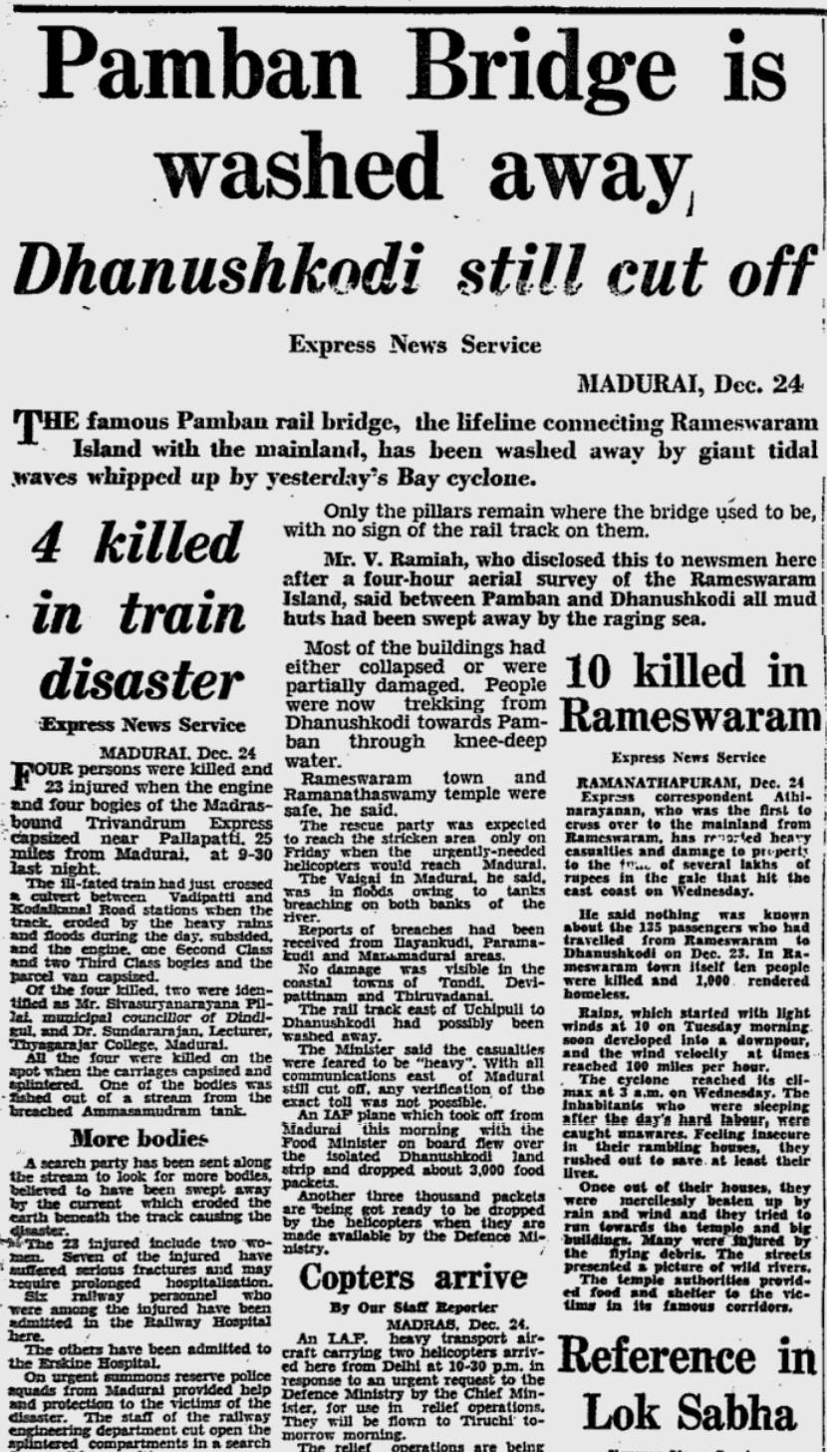
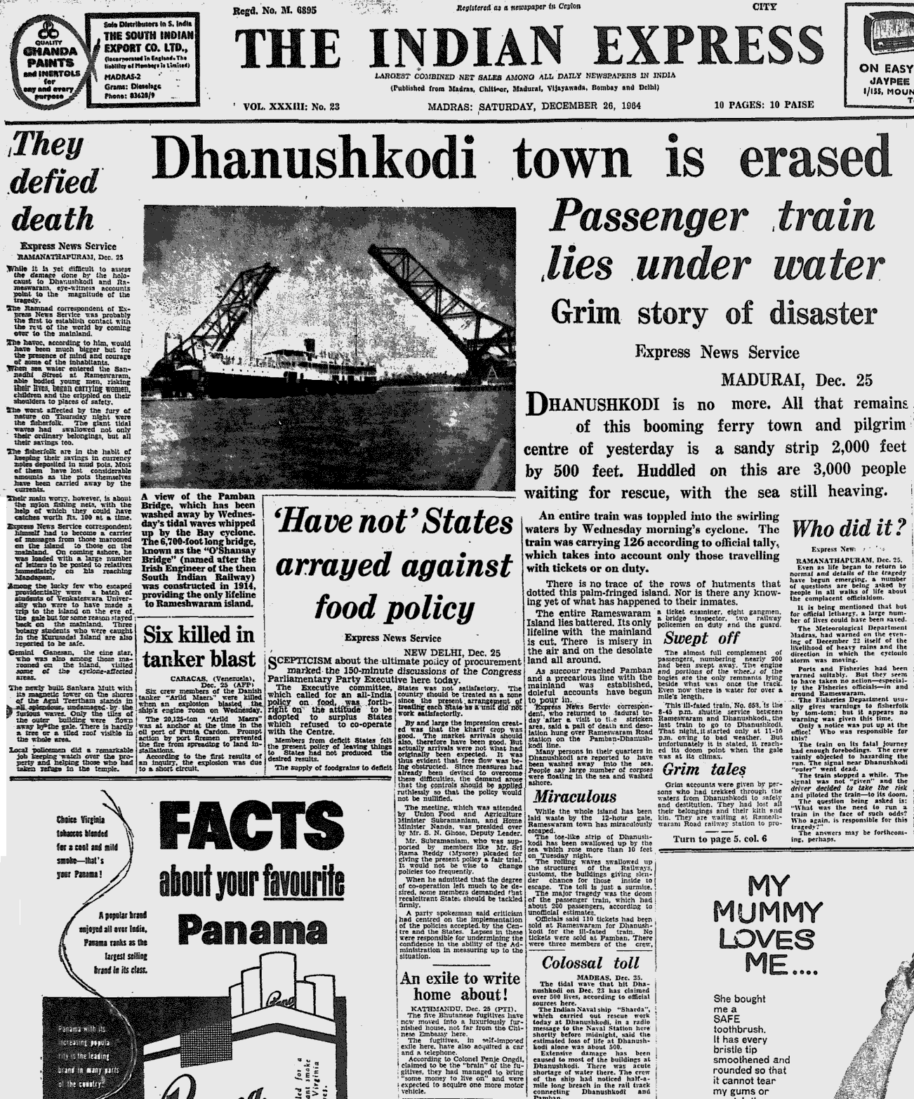
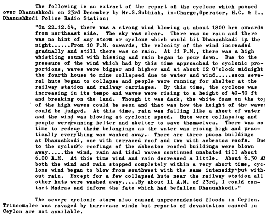
On December 23, 1964 early morning, the cyclone crossed Vavunia in Sri Lanka with a wind speed of 260-280 km per hour and it on mid day on December 23, the cyclone moved into Palk Strait and made the 2nd landfall in Dhanushkodi near Rameswaram island. Three things are threat from Cyclones one is the winds, storm surge and then extreme rains in short period of time. The devastating tidal waves that were 6 metres high submerged all houses and other structures in Dhanushkodi town with heavy casualties. By December 23rd evening the weakened storm had moved near Madurai.
The next day on December 24, 1964, the people of India woke up to the news of 1964 Dhanushkodi Super Cyclone wiping an entire town of Dhanushkodi. It was the only one super cyclone to hit the state of Tamil Nadu in last Century. We would have seen intense cyclones such as Thane (2011), Vardah (2016), Ockhi (2017) and Gaja (2018) these are wind wise very strong ones.
Estimated record wind speeds
Trincomalle in Sri Lanka witnessed wind speed was estimated between 220-280 km/hr while Vavunia town bore the full fury of the storm with estimated wind speeds of 280-330 km/hr. Remember this was from the 1st landfall in North Sri Lanka and it avoided the rugged terrain of Central-South Sri Lanka. But making landfall caused the cyclone to weaken and it moved into Palk Strait. Mannar reported 190-220 km/hr winds, Rameswaram reported 150-170 km/hr winds while Tondi reported 110-130 km/hr. As a very weakened cyclone into south interior Tamil Nadu, Madurai Reported 80-90 km/hr winds.
Rains from the cyclone
The cyclone dumped huge rains in Sri Lanka over 300 mm in some places around Vavunia. Rainfall caused its major impact in Madurai from the cyclone.
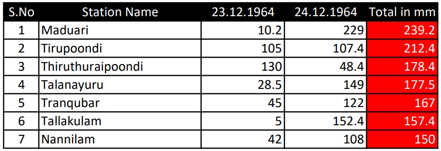
Rainfall compiled by me
It was the storm surge that caused the major damage
Once the winds started hitting, tidal waves that were 5-6 metres high submerged all houses and other structures in Dhanushkodi town with heavy casualties. The Tidal wave hit the Pamban-Dhanushkodi Passenger train and washed it into the sea while it was crossing the pamban bridge during the cyclonic storm 100-200 people died in that train alone.
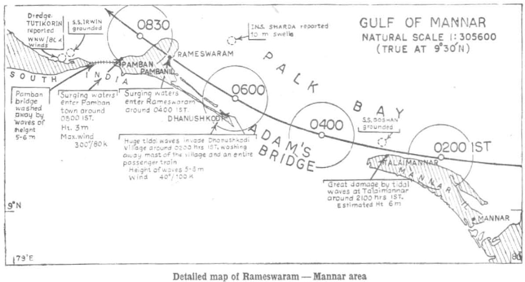
Photo Courtesy (NS. Bhaskar Rao & S.Mazumudar)
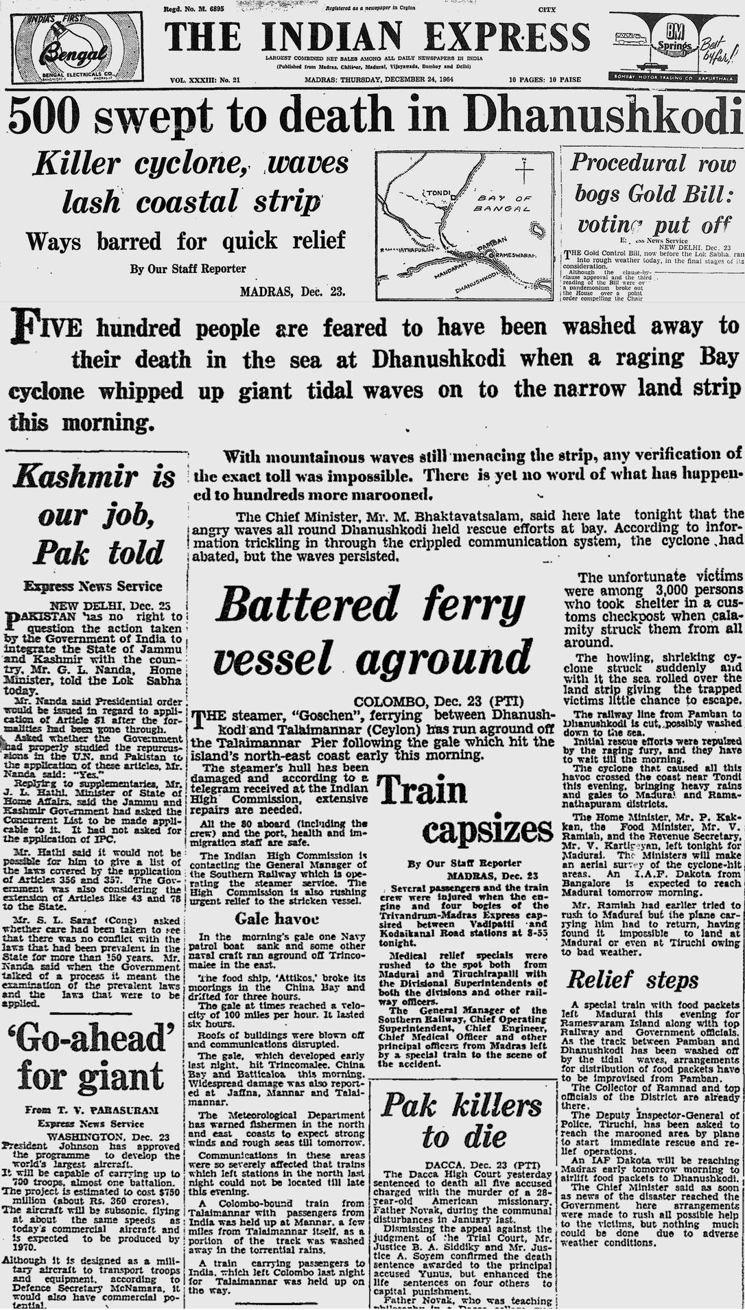
I have compiled the articles from newspapers (if the image is not clear, open in new wand also the cyclone summary of one deadliest cyclone to move into Tamil Nadu.

Courtesy NoAA
Compiled from inputs from Metoffice, Bombay and NoAA, United States. While collecting data found out that there was a interesting event in 1955 when a severe cyclone moved into Ramanathapuram-Pudukottai belt. Some places have 700 mm rains in 2-3 days there. Must be the heaviest rains recorded in Ramanathapuram district ever.


