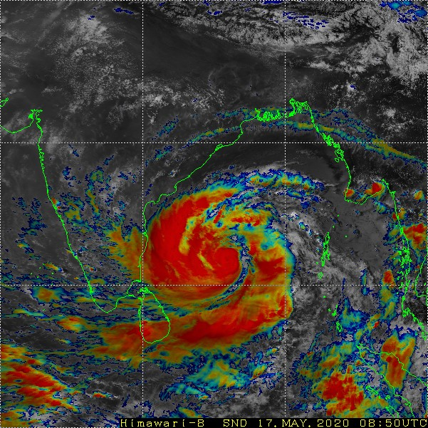
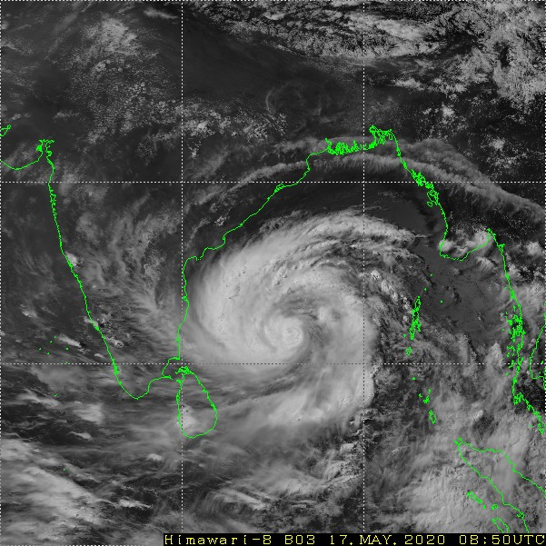
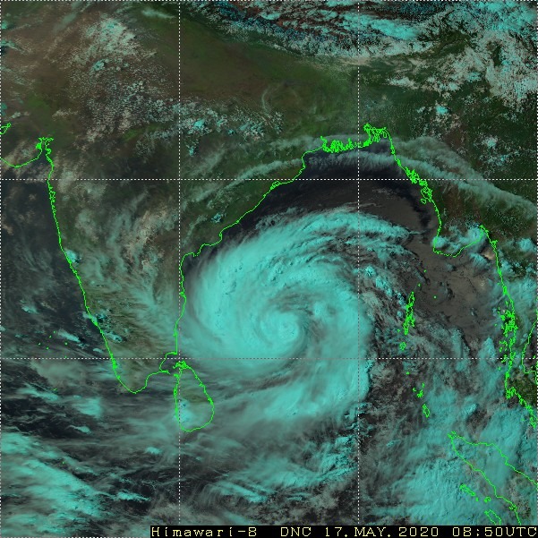
Amphan is a monster in making, North Odisha to Bengal/Bangladesh border (Sunderbans) are the hotspots for crossing the coast.
=================
Please read the last two posts before proceeding further to understand the trend. And most of ur answers will be found in these posts. Please read them before asking any questions.
May 13 – Facebook Post
May 15 – Facebook Post

1.How strong can get Amphan get ?
—————–
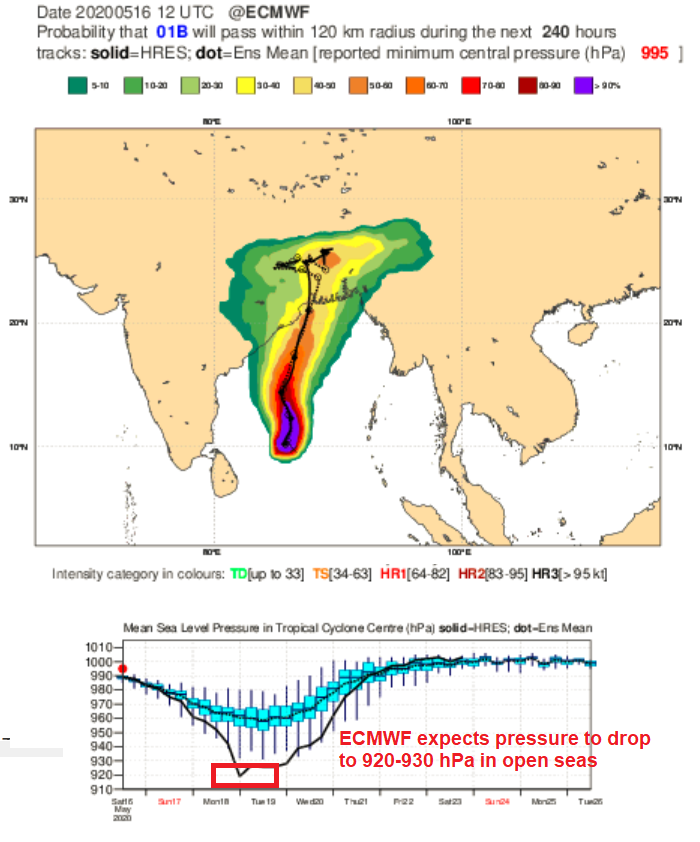
May month cyclones are usually strong and with low shear now, high SST, MJO in P3 with close to 1.5 amplitude, very high TCHP, this Amphan is a monster in making. Only when it goes further up close to Odisha latitude, it encounters increase in shear that should weaken a bit, still it will be a very strong cyclone at time of landfall. In open seas Amphan is surely expected to become a monster even 915-925hpa intensity can be expected but will slightly weaken to around 940-950 hpa at time of landfall.
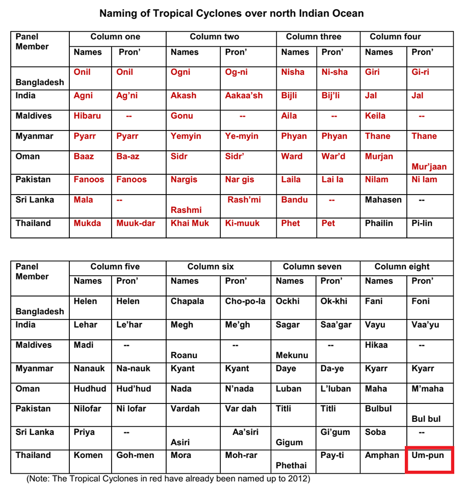
Regarding the confusion on the name. Its Amphan while writing while pronunciation it is Um-pun. For Fani it was Fani in writing while pronunciation it was Foni. See the image enclosed.
2. List of most intense Cyclone in Bay of Bengal & Arabian Sea
————————
1999 Odisha Cyclone – 912 hPa
1990 Andhra Pradesh Cyclone – 912 hPa
1991 Bangladesh – 918 hPa
1977 Andhra Pradesh Cyclone – 919 hPa
1963 Bangladesh Cyclone – 920 hPa
2007 Gonu (Arabian Sea) – 920 hPa
2019 Kyarr (Arabian Sea) – 922 hPa
1989 Gay – 930 hPa
2001 Gujarat Cyclone (Arabian Sea) – 932 hPa
2019 Fani – 932 hPa
Can Cyclone Amphan break into the list, there is high chance for the pressure to drop in open seas to 930 hpa later as it goes north, the wind shear is high and it should weaken a bit and does not cross at peak intensity. Cyclone Gaja had a pressure of 976 hPa, Vardah 975 hPa and Thane 969 hPa.
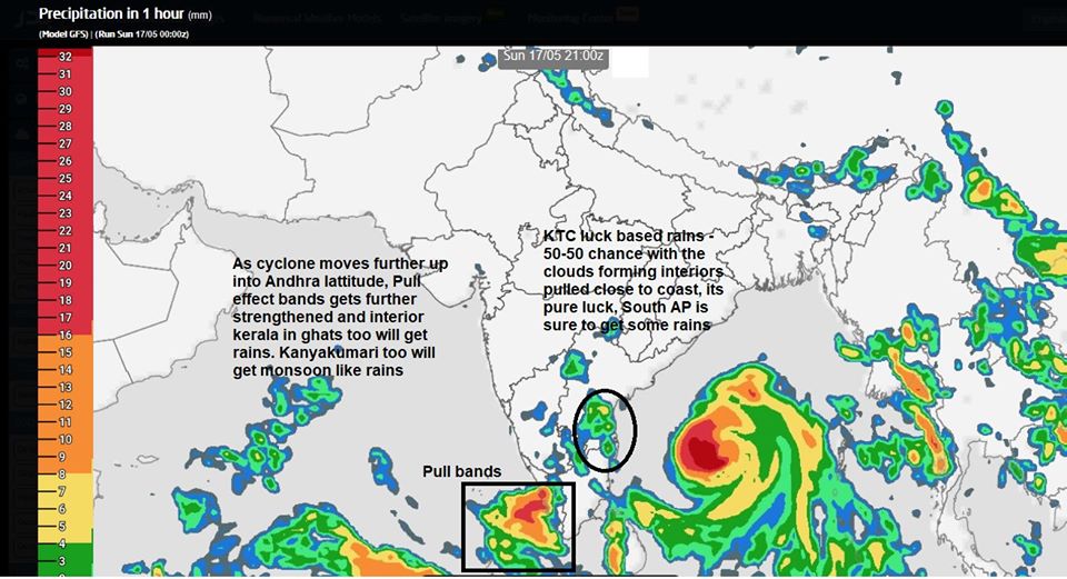
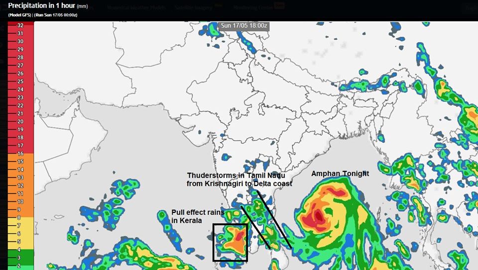
3. Rains for South India Peninsula – Kerala will see heavy rains from pull effect.
—————–
a. Kerala – Parts of Kerala coast are getting rains now with winds blowing parallel to coast, but as cyclone moves up above TN and not too far, the pull effect westerlies will hit kerala perpendicular this means winds can come into Kerala coast, there will be good rains in the ghat areas too. Rains in Kerala will reduce after 19th May. Some places Kerala might get over 100 mm rainfall. But there is 0% threat of floods.
b. Andhra – South AP to Chittor -Anantpur zone has chance of one day of TS. South AP areas such as Nellore has decent chance of rains.
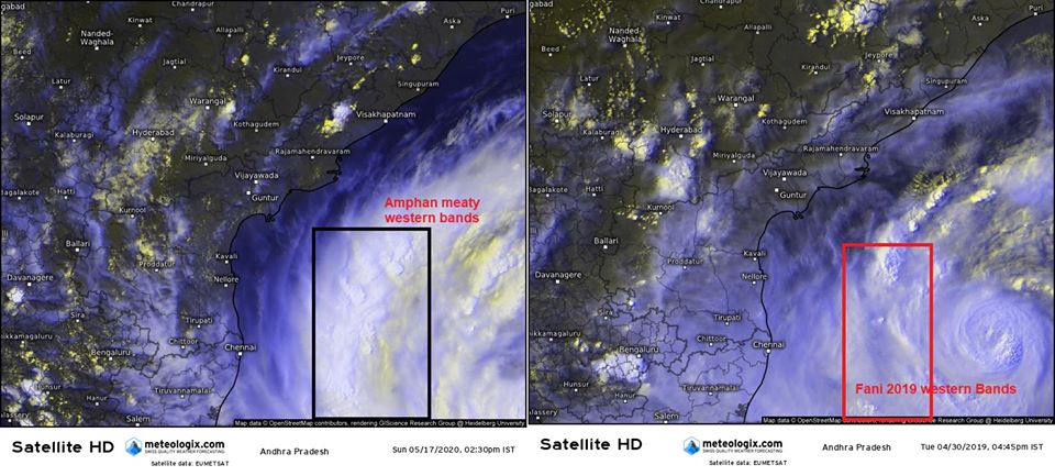
c. Tamil Nadu – Interiors will be filled with Intense Thunderstorms today and tomorrow. And one band is perfectly falling over Delta areas too.. Later at mornings the convergence shifts to NTN coast. If lucky KTC might get some spells but keep expectations too low. Chennai. All TS will be fast moving ones with gusts.
d. Karnataka – Managalore belt will pull effect rains like Kerala, the rains will be monsoon like. South Interior karnataka will see flare up of rains with high intense thunderstorms
During Thunderstorms, dont be in open water, dont tie ur animals to poles, dont leave ur farm animals in open fields. avoid playing in open fields during a thunderstorms.
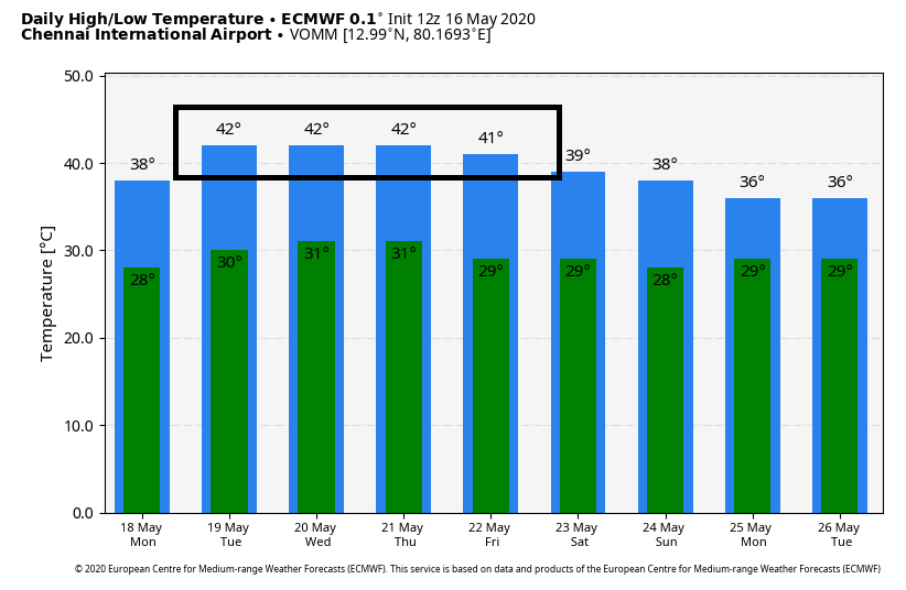
4. Dry heat for TN and Andhra – Hot day and night ahead
————–
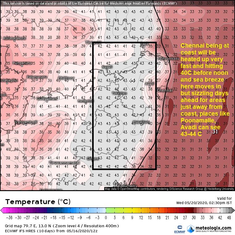
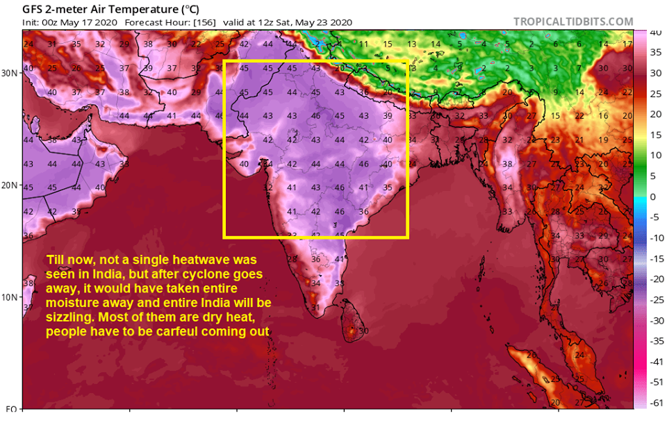
Refer previous post – From 19th, the dry heat in Rayalseema will be advected here to TN coastal belt. Chennai crossed 37 C yesterday, but thats below normal too. We will be seeing 40+ for sure from Tuesday with interior parts of Chennai City crossing even 42 C. Even at night the dry winds will be pulled towards us. So even at night 10 pm we can see hot winds. Entire Coastal areas and nearby interiors will be sizzling hot. While Kovai, Tiruppur, Erode which were sizzling will see westerlies like monsoon winds which means they will not be hot.
Possible Heat waves – While Chennai, Tiruvallur, Kancheepuram, Chengalpet, Cuddalore, Pondy, Nagapattinam, Ariyalur, Perambalur, Villupuram, Vellore, Tiruvannamalai, Kallakuruchi, Karaikkal all will see sizzling days for next 5-6 days from 18/19th May. Chennai from 19th May.
4. Was Amphan a heartbreak for Chennai / TN – No, unlike Fani, this was not. So Vada pogala. Fani was shown crashing into TN coast for days by models and then shifted. Amphan was clear, no cyclone rains to TN, if it is cyclone, it will miss us. Namma thaan ellathikum data compile panrom, lets see the heartbreak list
Heart breaks for Chennai
————————————-
a. Phethai (2018) NEM – Massive Bands missed Chennai by 50 kms. Chennai 0 mm rains & gusts of 40 km/hr witnessed from outer bands. One of the coldest day max Temp dipped to 26.8 C.
b. Jal (2010) NEM – So much expectations with direct landfall over Chennai but sheared and empty shell crossed City, 70 mm rains and wind speed 60 km/hr. Breezy day with maximum Temp dipping to 26.1 C
c. Gaja (2018) NEM – Complete miss for Chennai with 100 mm rains falling upto Chengalpet. Chennai got 5-10 mm rains. Nothing on gusts side for Chennai.
d. Madi (2013) – Went down without giving much to Chennai. Bands almost touched us. Chennai got 15 mm rains and gusts touched 35 km/hr.
e. Fani (2019) May – Expected to crash-into TN, the Bands went 300 kms away. Hottest day of the year 41.5 C and 0 mm rains.
f. Khaimhuk (2008) NEM – So close to Chennai. Chennai got 15-20 mm rains and gusts of 40km/hr was witnessed.
Amphan will not be added in the heartbreaks as it was clearly expected to move up once it was confirmed to become a strong cyclone. Had it been a LPA or UAC, then TN stood a chance. Even if it was a strong cyclone we would have got rains had it come closer by 250 kms from our coast, sadly it is going 500 kms away. In month of May only one strong cyclone has crossed close to Chennai it was in 1943 with Chennai getting close to 100 km/hr winds.
5. TNEB guys get ready to see increase in Demand for energy
6. Learn about the port warning signals, one need not fear just because it is announced in news.
Next update – If rains bands forms close to KTC or if anything is interesting.


